


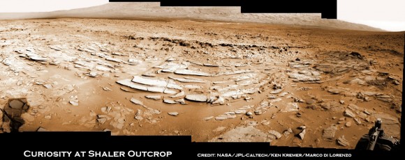
Image caption: Sol 120 colorized panorama of big and stunning ‘Shaler’ layered rock outcrop snapped by Curiosity’s right eye Navigation Camera (Navcam) on Dec. 7, 2012. ‘Shaler’ exhibits a pattern geologists refer to as ‘crossbedding’, at angles to one another. Some of the larger individual plates are about a foot or more wide. The cropped view spans from north at left to south at right. Future destination Mount Sharp is visible in the background. See the full 2-D panorama below and compare with the stereo effect available from NASA’s 3-D panorama, below. Credit: NASA/JPL-Caltech/Ken Kremer/Marco Di Lorenzo
NASA’s Curiosity rover is on the final steps of her descent into a geologist’s paradise at an area called ‘Yellowknife Bay’.
Along the way just days ago on Sol 120 (Dec 7, 2012) she stopped to inspect a huge outcrop of layered rocks dubbed ‘Shaler’ and snapped dozens of high resolution photos with the Navcam and Mastcam cameras.
The ‘Shaler’ outcrop features a plethora of striking layers, angled to each other in a pattern geologists refer to as ‘crossbedding’.
Read more: http://www.universetoday.com/98973/c...-drill-target/

 Reply With Quote